Status:
On original site
Type:
Other
Location:
External
Setting:
Within a garden/park/churchyard/enclosure/Marketplace
Description:
Other
Materials:
- Flora and Fauna Flora and Fauna (any)
Conflicts:
- First World War (1914-1918)
About the memorial:
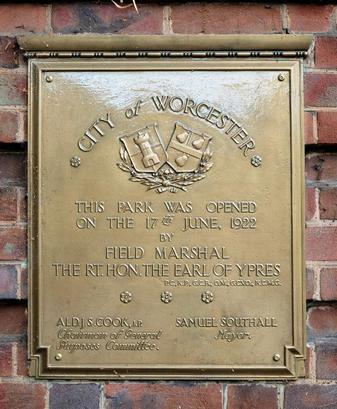
The battle of Gheluvelt was an early engagement in the First World War. The British Expeditionary Force had established a line to prevent the German forces reaching the Channel ports. On 31 October 1914 the Germans broke through this line and the 2nd Battalion of the Worcestershire regiment was sent to plug the gap and did so with a bayonet charge in the grounds of the Chateau at Gheluvelt in Flanders. They pushed back the German force of more than a thousand men, but with the loss to the battalion of 34 men and 158 injured. The victory was seen by many as highly significant, and a turning point in the early history of the war. At the opening of the park, on 17 June 1922, Field Marshal John French said that 'on that day the 2nd Worcesters saved the British Empire'.
Worcester City Council agreed to buy the land and existing buildings for £2,300 in January 1918, and to accept the mayor’s offer to subsidise the purchase. On 6 September 1918 Alderman Alfred Hill Parker, an architect with an office in Worcester, presented a plan for the layout of the park, and it was also agreed that the land should be known as Gheluvelt Park in commemoration of the significant victory won by the Worcesters. An estimate for £3,230 to lay out the park was presented by the borough engineer in February 1920. A broad roadway was planned in front of the homes for ex-servicemen, and land to the west, which included the former pleasure grounds and paddock of Barbourne House, was raised by the tipping of town waste to create a series of four terraces with turf slopes or rockeries on the northern side of the park, gradually sloping towards the brook and the pond on the south side. pond, In March 1920 it was decided to include recreation areas, amongst them a children’s playground and a tarmac 'beach' to the south side of Barbourne Brook, plus six tennis courts. These alterations, as well as the need to make the bed of the brook safe for children by means of a concrete lining, pushed the estimated cost up to £4,540. The mayor offered a drinking fountain in October 1922 so that children would not drink out of the brook, and in May 1923 the High Sheriff of Worcestershire, Alfred Wiggin, gave the bandstand to be set on the island in the pond, while a third donor, Mr James Ward, offered the bridge to get to it. Twelve houses for ex-soldiers and seamen, also designed by Alfred Hill Parker, were built along the northern side of the park in 1919-20.
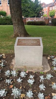
The park area is bounded by Lavender Road to its north and Barbourne Lane and Waterworks Road to the south. The Barbourne Brook runs through the park and continues to join with the River Severn which lies ¼ mile to the west.The principal approach is from the Barbourne Road to the east. The main entrance consists of a brick memorial arch, erected c. 1924 with accompanying lateral gates, screens and wing walls, designed by Alfred Hill Parker (WMO 255506). In addition to the memorial archway and gates the park contains twelve houses which were built as homes for wounded sailors and soldiers (WMO 255516). The bandstand (WMO 255515) is sited on an island in the middle of the pond, with both forming a central feature of the landscape. The bandstand is approached by a timber bridge set on masonry cutwaters.
The park developed out of the large garden of a late-C18 suburban house, and this landscape was itself partly formed by the Barbourne Brook which runs across the land and the large, club-shaped pond which is a remnant of the fulling ground which occupied the site in the early C18. The park has evolved over the course of almost a century since it was opened as a memorial to those who died in the First World War, but the overall plan with distinct areas for recreation, housing and open lawns with banks of trees and flower beds has remained as it was conceived. The houses for servicemen are positioned at the north of the site. This is similar to the placing of the former Barbourne House and takes advantage of the sloping southern views across the site towards central Worcester and also helps to raise the buildings out of the flood plain of the Barbourne Brook and the River Severn.
To the south of the housing at a lower level is the pond with its island and bandstand, these built elements forming a central N-S axis. The most notable cross axis is the broad driveway which runs from the entrance arch at the north-east corner in front of the servicemen’s houses, connecting them and giving an air of formality to their setting. It is placed on the topmost terrace with flowerbeds to either side. Below this is the interactive water feature, which has now replaced the former paddling pool. Around these central elements of housing, pool and bandstand are further flowerbeds. To the east of this the park has a lawned area crossed by paths, and planted with mature deciduous trees and younger, specimen trees. The mature trees have made this formerly open area shady in the summer. The eastern boundary has a belt of deciduous trees forming a screen to the Barbourne Road. To the west of centre is a further lawned area with tennis courts in their original position and the site of the former tennis pavilion, given by Richard Cadbury, but which has now been lost.
The war memorial of 2010 by Plincke Landscapes (WMO 140797) is set in the south-east corner, slightly to the north of the brook and consists of a circular arrangement of Corten steel panels, representing the fallen from various engagements and battles of the First World War.
Edit memorial details